
18 Best Hikes In Northern California: The Top-Rated Hiking Trails To Visit In 2024

Jasmine Vieau
Author
Many of us are looking for ways to connect with nature and explore the great outdoors. One of the best ways to do this is by hiking, and Northern California is home to some epic trails. To help you plan your next adventure, we’ve put together a list of the best hikes in Northern California. These trails have been highly rated by fellow hikers and offer some of the most stunning scenery in the region. So whether you’re a seasoned hiker or just starting, add these top-rated hiking trails to your bucket list. Happy trails!
Best Hikes in Northern California
Northern California is home to some of the best hikes in the country, with picturesque summits and challenging trails that attract outdoor enthusiasts from all over. One of the most popular hikes in the area is the Mist Trail to Vernal and Nevada Falls, which offers beautiful waterfalls and breathtaking vistas. Another great option is the Upper Yosemite Falls Trail, which takes hikers to the top of the tallest waterfall in North America. For those looking for a unique experience, the Devil’s Slide Trail is a must-try, with its steep inclines and panoramic views of the Pacific Ocean. No matter which trail you choose, you’re sure to have an unforgettable adventure in Northern California’s great outdoors.
1. Vernal and Nevada Falls via Mist Trail
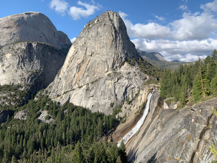
- Location: Yosemite Valley
- Mileage: 6.4-mile loop trail
- Difficulty: Hard
- FYI: Yosemite National Park is a popular hiking destination. Visit between May and October for the best experience. Dogs are not allowed on this trail. Entry fee required.
Check out the Vernal and Nevada Falls on the Mist Trail, one of Yosemite's top hiking trails. This is a must-do hike if you want to break a sweat. You'll be so close to the falls that you might get wet from the trail. Spring and early summer are the best times to go when the snow runoff is high and the falls are at their fullest.
2. Upper Yosemite Falls Trail
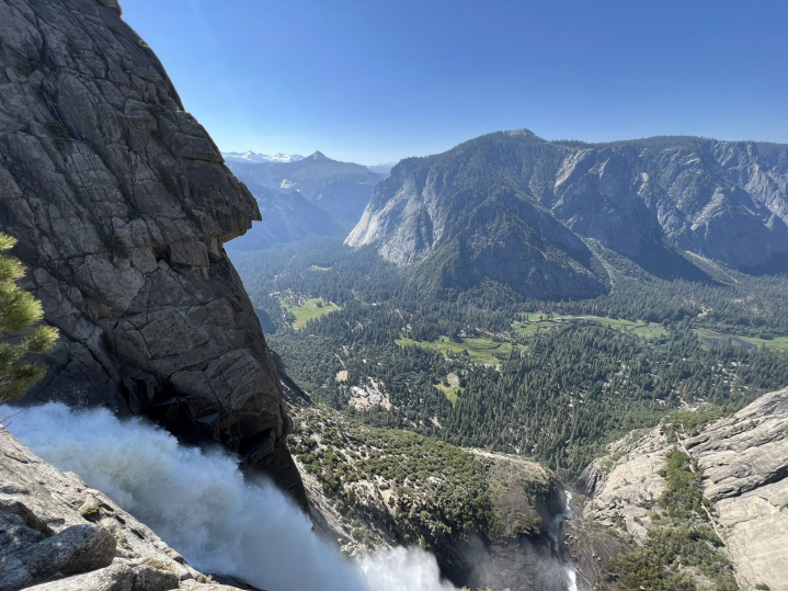
- Location: Yosemite Valley
- Mileage: 6.6-mile out-and-back trail
- Difficulty: Hard
- FYI: Yosemite National Park is a popular area for backpacking, camping, and hiking. Visit between April and October, but leave your dogs at home as they are not allowed on this trail. Entry fee required.
Visit Upper Yosemite Falls Trail for incredible views of Yosemite Falls, the tallest waterfall in the US. The falls consist of three sections: upper falls, middle cascade, and lower falls. While lower falls are more popular, upper falls offer panoramic views of Yosemite Valley and the chance to see the waterfall up close.
3. Devils Slide Trail

- Location: Idyllwild-Pine Cove
- Mileage: 6.6-mile out-and-back trail
- Difficulty: Moderate
- FYI: This hiking area is popular, so expect to encounter other hikers. Dogs are welcome and may be off-leash in certain areas. Keep in mind that a free permit is required for both day hikes and overnight trips within the federal wilderness area.
Devils Slide Trail is a 6.6-mile hike near Idyllwild-Pine Cove, California. It's moderately challenging and takes around four hours to complete. Microspikes, waterproof shoes, and trekking poles are highly recommended, especially during the snowy season. Get there early in the morning, and enjoy beautiful views and lots of trees along the way. There's good shade in the morning, and the incline is steady but not too hard.
Best Short & Easy Hikes in Northern California
For some great short and easy hikes in Northern California, look no further than the Lower Yosemite Falls Trail, the Cosumnes River Walk Trail, and Bumpass Hell. These hikes offer beautiful scenery, moderate difficulty, and a chance to get outside and enjoy nature without strenuous climbing or hiking.
4. Lower Yosemite Falls Trail
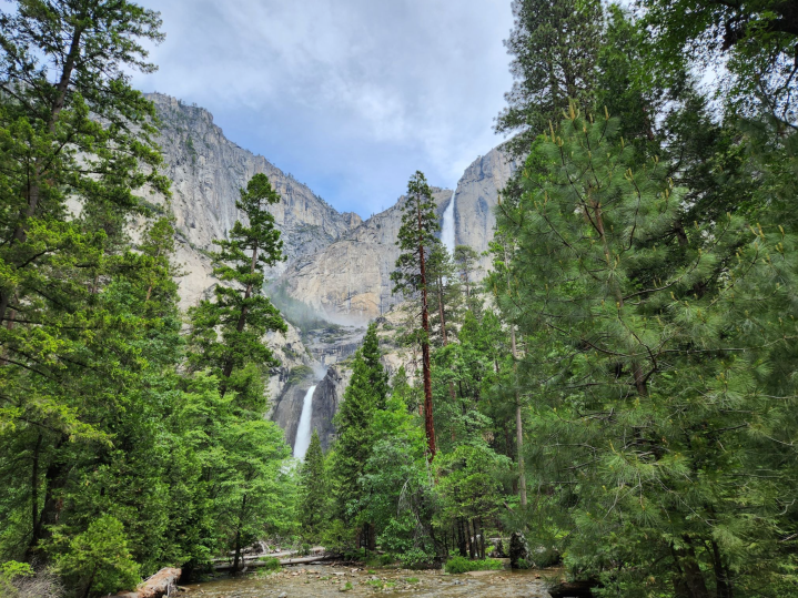
- Location: Yosemite Valley
- Mileage: 1.2-mile loop trail
- Difficulty: Easy
- FYI: Yosemite National Park is a popular area for walking, offering year-round beauty. Expect to encounter other people on the trail. Dogs are welcome but must be on a leash. Entry to Yosemite National Park requires a fee.
Take a quick stroll on the Lower Yosemite Falls Trail to see the impressive Yosemite Falls. This waterfall is the tallest in Northern America and fifth in the world. The trail is accessible all year but can be slippery in the winter. You can start your walk at the Lower Yosemite Falls Trailhead. The route is short and easy, and offers breathtaking views of all three waterfalls. The best time to see it is in the spring when the snow melts and the upper lakes are full, creating a powerful water flow.
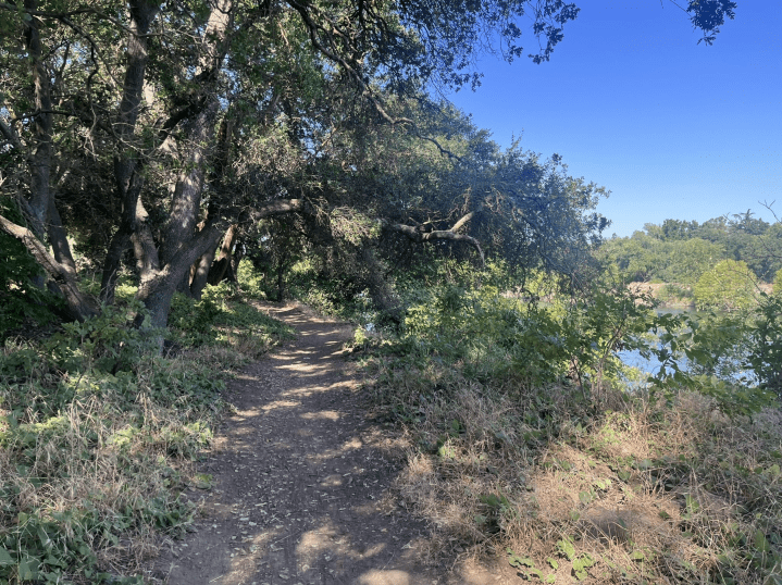
5. Cosumnes River Walk Trail
- Location: Galt
- Mileage: 3.2-mile loop trail
- Difficulty: Easy
- FYI: Perfect for birding, hiking, or running. However, be aware it's a popular spot, so you'll likely run into other people. The trail is open all year long, and dogs aren't allowed.
The Cosumnes River Walk Trail in Galt is a 3.2-mile loop that's easy to complete in just under an hour. It's a beautiful route with river views and wildflowers, perfect for families with kids. Don't forget to stop by the visitor center!
6. Bumpass Hell
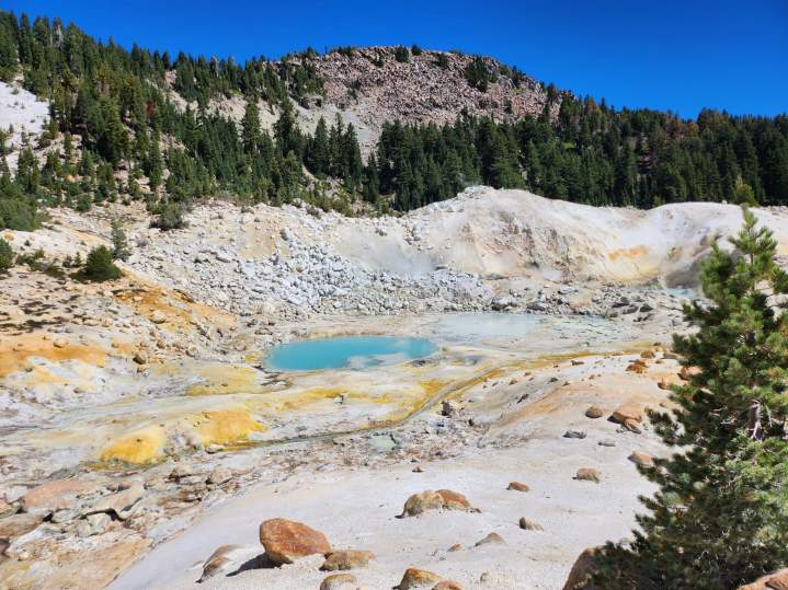
- Location: Mineral
- Mileage: 2.7-mile out-and-back trail
- Difficulty: Easy
- FYI: Expect to see other people if you hike or run here. The best time to visit is between June and October. Dogs are not allowed on the trail, so leave them at home. Remember that there is an admission fee to enter Lassen Volcanic National Park.
If you're up for an adventure, visiting Bumpass Hell in California is a must-do. The bubbling mud pots, sulfur vents, and boiling pools make it feel like you're visiting "hell" and back. Along the way, there are plenty of informative signs to teach you about the local geology. It's important to stick to the trail, as Kendal Bumpass discovered the hard way when he fell in and injured his leg twice, requiring amputation. But don't let that scare you away, this is an easy and family-friendly hike with little danger as long as you stay on the trail.
Hardest Hikes in Northern California
Northern California has some challenging hikes, including the EURL, Mount Tallac Trail, and Alamere Falls via Coast Trail from Palomarin Trailhead. These hikes require physical endurance and mental fortitude but offer breathtaking views and a sense of accomplishment. If you’re up for the challenge, these hikes are worth adding to your list of hikes to try.
7. EURL (Ebbets Ultimate Ridge Linkup)

- Location: Markleeville
- Mileage: 18.2-mile loop trail
- Difficulty: Hard
- FYI: This is a great hiking trail with limited crowds. The best time to visit is between May and November. Overnight trips require a Wilderness Permit, while a trailhead permit is needed for day use in the Carson Pass Management Area.
EURL (Ebbets Ultimate Ridge Linkup) is a challenging ridge traverse and scramble near Markleeville in the Mokelumne Wilderness. It requires mountaineering experience, endurance, and perseverance.
8. Mount Tallac Trail
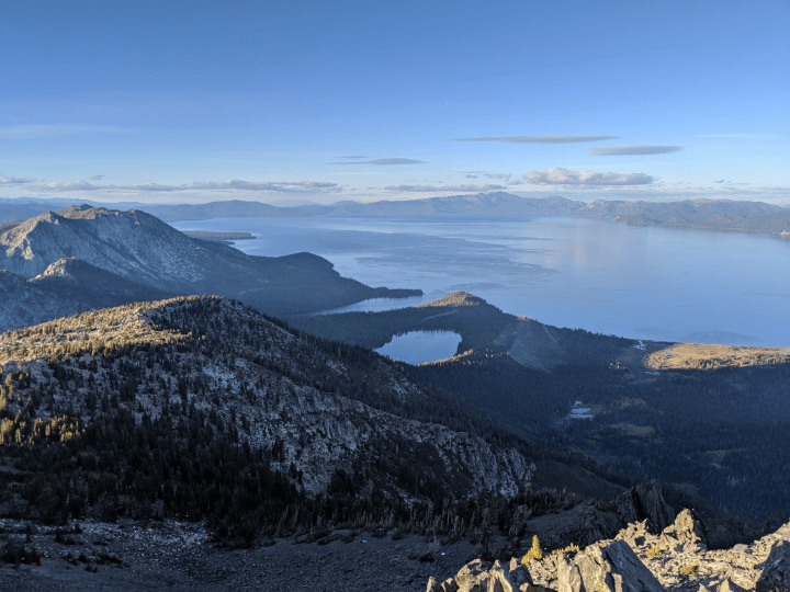
- Location: South Lake Tahoe
- Mileage: 10.1-mile out-and-back trail
- Difficulty: Hard
- FYI: This hiking area is popular for hiking and snowshoeing, so expect to see other people. The best times to visit are May through October. Dogs are allowed, but must be leashed.
Mount Tallac is a famous day hike in Tahoe that offers stunning views of Lake Tahoe from its summit at 9,735 feet above sea level. You'll start at the Tallac Trailhead parking lot, about a mile from Highway 89 across from Baldwin Beach. The trail begins with a gradual climb along a ridgeline that provides fantastic views of Fallen Leaf Lake. Along the way, you'll come across two alpine lakes: Floating Island Lake and Cathedral Lake. Once you pass Cathedral Lake, the trail becomes steeper and rockier as you exit the treeline. From here, you'll see Gilmore Lake and the summit of Tallac.
As you near the top, don't forget to appreciate the magnificent views of Emerald Bay and South Lake Tahoe. These views are unparalleled in Tahoe. Mount Tallac is also a popular winter route for backcountry skiers and snowshoers. However, be careful of avalanches and avoid hiking alone.
9. Alamere Falls via Coast Trail from Palomarin Trailhead
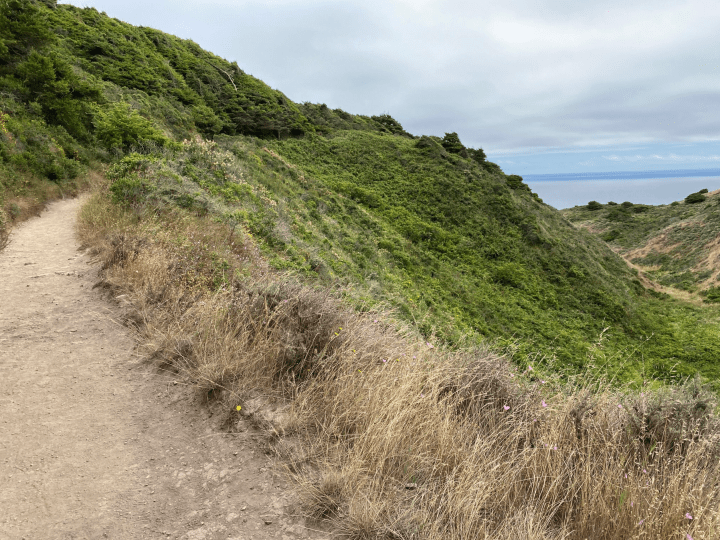
- Location: Bolinas
- Mileage: 13.7-mile out-and-back trail
- Difficulty: Hard
- FYI: This popular trail is great for birding or hiking year-round, but no dogs allowed. Expect other people.
Alamere Falls is a beautiful waterfall that flows into the Pacific Ocean, located in Point Reyes National Seashore, northwest of San Francisco. You can start the hike to Alamere Falls from the Coast Trail via the Palomarin Trailhead. The trail offers gorgeous ocean views, including sights of the Farallon Islands on a clear day, Bass Lake, Pelican Lake, Ocean Lake, and Wildcat Lake.
Best Waterfront Hikes in Northern California
The Cataract Falls Trail, Mirror Lake Loop, and Eagle Lake Trail are three top waterfront hiking options for outdoor enthusiasts. Each trail offers water views and beautiful surrounding landscapes, making them perfect for a day trip or weekend adventure. Whether you’re looking for a challenging hike or a relaxed stroll, these trails have something for everyone.
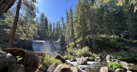
10. Cataract Falls Trail
- Location: Stinson Beach
- Mileage: 2.8-mile out-and-back trail
- Difficulty: Moderate
- FYI: This trail is busy year-round and dogs must be leashed. A fee is charged to park at Mount Tamalpais Watershed.
Cataract Falls is a really popular trail for waterfalls in Marin County, in the San Francisco Bay Area. It's a nice hike with lots of little waterfalls throughout the route. You start at Bolinas Fairfax Road, just past Alpine Lake. Even though it's not a long hike, you'll still get a good workout because of the uphill parts. The best time to go is after it's rained when the water is flowing.
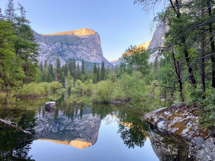
11. Mirror Lake Loop
- Location: Yosemite Valley
- Mileage: 5.0-mile loop trail
- Difficulty: Easy
- FYI: This trail is popular for hiking and running, but expect crowds. April through October is the best time to visit. Sorry, no pups allowed on this trail. There's also a fee to park at Yosemite National Park.
Mirror Lake Loop is a fun and easy hike. From the base of Half Dome, you can see Tenaya Canyon, Mount Watkins, and Washington Column. Mirror Lake is fullest in the spring and early summer, offering stunning reflections on calm waters. In late summer, Mirror Lake is often dry and referred to as Mirror Meadow.
To access the loop trail, follow the paved service road for the first mile. The loop takes you past Tenaya Creek, over two bridges, and returns you to Mirror Lake on the south side of Tenaya Canyon. Please note that there is no safe access to the north side of Mirror Lake from the south side of the loop.
12. Eagle Lake Trail
- Location: South Lake Tahoe
- Mileage: 1.9-mile out-and-back trail
- Difficulty: Moderate
- FYI: This is a popular hiking area, so expect others to be around. Best times to visit are May through October. Dogs welcome on leash.
The Eagle Falls Trail is an excellent place for the whole family to explore. You'll find waterfalls, creeks, lakes, granite peaks, and lush vegetation here. After getting your permit at the trailhead, head southwest and climb some stone steps to see the falls. If you're going to the lake, follow the route uphill for about half a mile until you reach a fork. Take the right trail to the lake, where you can swim or enjoy the views.
Best Winter Hikes in Northern California
If you’re looking for some winter hikes and a peaceful break from the hustle and bustle of city life, you should check out Lassen Peak, Tahoe Rim Trail to Picnic Rock Viewpoint, and Bear Valley Mountain Ski Resort to Bear Lake. Bring plenty of warm clothes and your trusty hiking shoes, and prepare to have some wintertime fun.
13. Lassen Peak Trail

- Location: Mineral
- Mileage: 4.9-mile out-and-back trail
- Difficulty: Hard
- FYI: This hiking area is popular and often busy. The trail is open year-round and offers great views. Sorry, no dogs allowed. There is an entrance fee to Lassen Volcanic National Park.
Lassen Peak is a must-see for anyone visiting Lassen National Park. It's the tallest peak in the park and offers stunning views of the surrounding area. The hike to the top is tough, but the scenery is worth it. Lassen is a unique volcano, with different vents erupting in recent years. It's a lava dome and one of only two volcanoes in the US to erupt in the 20th century.
14. Tahoe Rim Trail to Picnic Rock Viewpoint
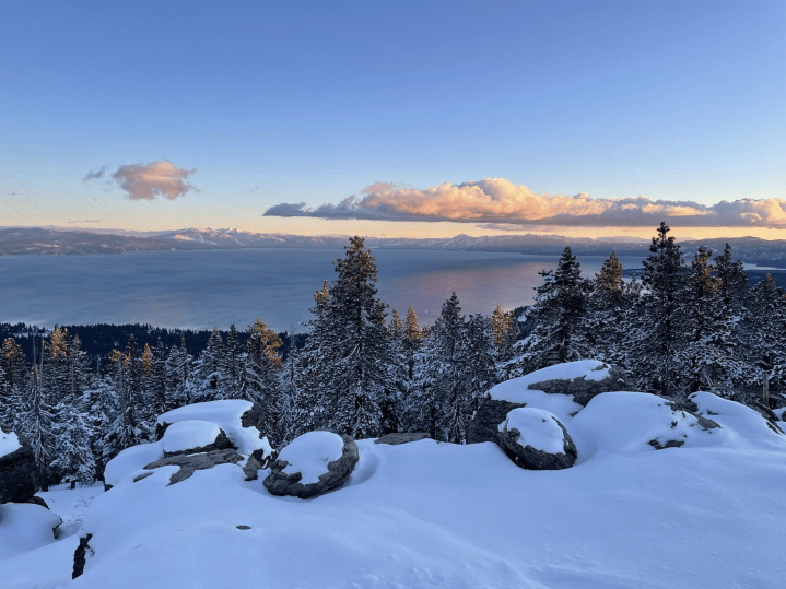
- Location: Kings Beach
- Mileage: 3.1-mile out-and-back trail
- Difficulty: Moderate
- FYI: This hiking area is popular and often busy. The trail is open year-round and beautiful to visit anytime. Dogs are welcome, but must be on a leash.
If you're looking for a short and sweet hike in the Tahoe area with epic views of Lake Tahoe and surrounding peaks, this trail is a must-do. The trailhead is located up the hill from Northstar, between Truckee and Kings Beach in North Lake Tahoe. The trail is a smooth single track that can be extended into a longer hike if desired by staying on the Rim Trail. If you're just interested in the viewpoint, keep an eye out for a tree with an arrow-shaped sign reading "Picnic Rock Lake View" about a mile in. There is no water source along the trail, but you'll find some shade to keep you cool on warmer days.
15. Bear Valley Mountain Ski Resort to Bear Lake
- Location: Markleeville
- Mileage: 3.4-mile out-and-back trail
- Difficulty: Easy
- FYI: This trail is perfect for hiking, skiing, and running. It's least crowded from November to April. You can bring your dog, but make sure to keep them on a leash in certain parts.
Have you tried hiking the 3.4-mile out-and-back trail near Markleeville? It's a great route that takes an hour and a half to complete. The trek is generally considered easy and is perfect for hiking, skiing, and running. You'll love the pretty views over most of the hike, which is basically a relaxing out-and-back on a 4x4 road. Plus, the trail is near Bear Lake in Stanislaus National Forest.
Best Hikes near Sacramento
If you’re looking for hiking spots near Sacramento, you’re in luck! There are plenty of trails to explore in the area. Some popular options include the American River Parkway, Guy West Bridge to Watt Avenue Bridge, and the Capitol Park Loop Trail.
16. Guy West Bridge to Watt Avenue Bridge
- Location: Sacramento
- Mileage: 5.1-mile loop trail
- Difficulty: Easy
- FYI: This spot is great for birding, fishing, and road biking, but it can get crowded. The trail is always open and beautiful. Leashed dogs are allowed.
There's a lovely 5.1-mile loop trail near Sacramento that's fairly easy to navigate. Most people finish it in about an hour and a half. It's a favorite spot for birdwatching, fishing, and road biking. The trail is paved and runs alongside the river, offering some beautiful views from the bridges. If you prefer a more rustic experience, there's also a dirt and gravel trail that hugs the riverbank. It's a great trail for families with kids and is also wheelchair accessible.
17. American River Bike Trail (Jedediah Smith Memorial Trail)
- Location: Sacramento
- Mileage: 32.3-mile point-to-point trail
- Difficulty: Easy
- FYI: Expect crowds when exploring this popular spot for horseback riding, running, and road biking. The trail is always open and stunning, making it a great year-round destination. Don't forget to leash your pup.
The American River Bike Trail, also called the Jedediah Smith Trail, is a smooth path that goes alongside the American River. It's a great trail with beautiful views of the river and starts at Discovery Park in Sacramento and ends at Beal's Point in Folsom, running for 31 miles. You can enter the trail from different places like roads, parks, and neighborhoods. Some trails lead down to the river, but they might be a bit steeper and narrower. If you need a break, there are benches along the way, and you can find accessible restrooms too.
18. Capitol Park Loop Trail
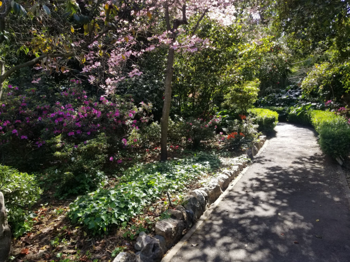
- Location: Sacramento
- Mileage: 1.1-mile loop trail
- Difficulty: Easy
- FYI: This is a popular spot for running and walking, so expect a crowd. The trail is always open and beautiful, making it a great year-round destination. Dogs are welcome, but must be on a leash.
Capitol Park Loop Trail is a 1.1-mile loop with lots of cool stuff to see, like the Capitol building, war memorials, a cacti garden, 100 different types of trees, and a world peace rose garden and fountain. There are also plenty of shady spots in the park for a picnic. The trail should be easy to navigate for most wheelchairs, mobility equipment, or strollers, and there are benches along the way if you need to take a break. Worth checking out if you're in Sacramento.
Have you explored these best hiking trails in Northern California? Are they the top hiking trails and best places to hike in Northern California? Let us know – we’re excited to hear from you!
Whether you’re an experienced hiker seeking elevation gain and switchbacks or a beginner looking for a day hike, the Northern California Nature Hub offers a wide range of options to meet your needs. And don’t forget to take advantage of the opportunity to try Try AllTrails+ For Free, providing you with even more resources and features for your hiking adventures!
OnlyInYourState may earn compensation through affiliate links in this article. As an Amazon Associate, we earn from qualifying purchases.
More to Explore
Hiking Trails In Northern California
Does Northern California have good hiking trails?
Northern California's best hiking trails include:
- Burney Falls Loop Trail in McArthur-Burney Falls Memorial State Park
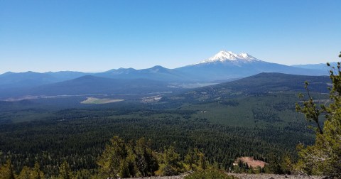
- Mount Shasta via Avalanche Gulch Route
- Big Sur River Gorge Trail
- Across the Golden Gate Bridge to Sausalito
- Fern Canyon Loop in Prairie Creek Redwoods State Park
- Crags Trail to Castle Dome
- California Coastal Trail
- Lady Bird Johnson Grove Trail in Redwood National Park
- Muir Woods Fern Creek Loop
- Armstrong Redwood Grove Loop Trail
What are the best months to hike in Northern California?
If you're doing some Northern California hiking, we'd recommend going during the summer or early fall if you're hitting the mountains. If you're looking to explore the low-lying parts of the state, spring, and fall are generally the most pleasant times to do so. Winter snow can make hiking difficult from around October or November through early July, so if you're looking for normal dry-trail conditions, you'll want to wait until the snow has melted.